NEWSLETTER

Get the latest updates, news, and insights right in your inbox!
Greater Collinwood Logo Greater Collinwood Logo 2
Search
  • Home
  • News
  • Business
  • Money
  • Technology
  • Sports
  • Health
  • Life Style
  • Travel
Reading: Relentless Storm System Drenches Southeast, Threatens Floods from Gulf Coast to Virginia
Share
Font ResizerAa
Greater CollinwoodGreater Collinwood
  • News
  • Politics
  • World
  • Business
  • Money
  • Technology
  • Sports
Search
  • Home
  • News
  • Business
  • Money
  • Technology
  • Sports
  • Life Style
  • Culture
  • Education
  • Health
  • Travel
Follow US
© 2024 Greater Collinwood | All Rights Reserved |
Greater Collinwood > Blog > News > Relentless Storm System Drenches Southeast, Threatens Floods from Gulf Coast to Virginia

Relentless Storm System Drenches Southeast, Threatens Floods from Gulf Coast to Virginia

Jason Flack
Share
Relentless Storm System Drenches Southeast, Threatens Floods from Gulf Coast to Virginia

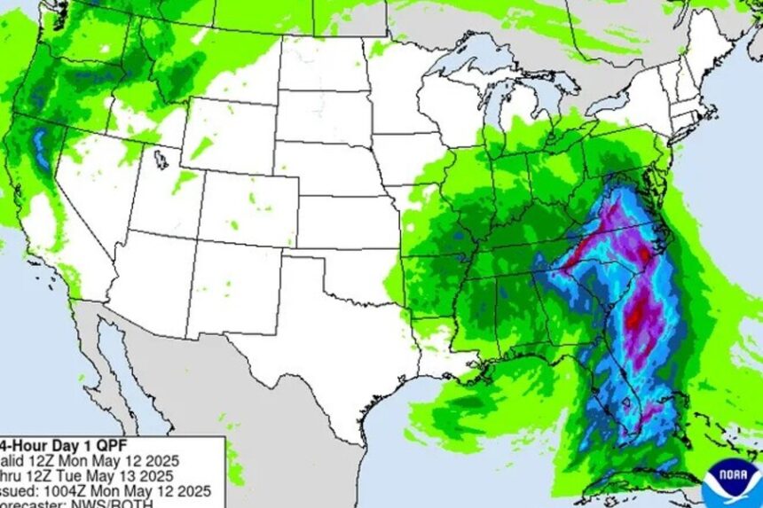
A powerful and slow-moving storm system is hammering the southeastern United States this week, unleashing torrential rains, triggering flash flood warnings, and creating widespread disruptions from the Gulf Coast up through Virginia.

Beginning Monday, the system has already dumped inches of rain across several states, prompting flood watches and advisories stretching from Florida to the Carolinas. Meteorologists say the danger is far from over. About 36 million people along the Eastern Seaboard remain at risk of severe weather, including damaging winds, hail, and isolated tornadoes, according to the Storm Prediction Center.

AccuWeather forecasts predict that a dozen states could see over 2 inches of rain in the coming days. Parts of southern Georgia, Alabama, and especially Florida may receive up to 10 inches, nearly two months’ worth of rain in less than a week. The flood potential is particularly high in South Florida, central Alabama, and the Carolinas, where saturated soil and overwhelmed waterways raise the risk of flash flooding.

In North Carolina, up to 4 inches of rain had already fallen by Monday afternoon. The National Weather Service office in Morehead City warned that conditions posed “life-threatening flash flooding of creeks and streams, urban areas, highways, streets, and underpasses.” Officials there say the state could be seeing its heaviest rain since Hurricane Helene in 2018.

The storm system is also being blamed for a severe weather outbreak over the weekend, which produced tornadoes that struck areas of Florida, including Destin and Esto, leaving widespread damage.

The impact of the storm isn’t limited to rainfall. Across Florida, Georgia, and Alabama, more than 20,000 homes and businesses lost power as of Monday, with Florida experiencing the most outages. Miami-Dade and Broward counties alone reported over 3,000 customers without electricity, according to PowerOutage.us.

Meanwhile, major airports have begun experiencing significant delays. Miami International Airport saw over 40 flight cancellations and around 160 delays, with average departure wait times reaching 90 minutes. The Federal Aviation Administration warned of possible ground stops at airports in Tampa, Miami, and Atlanta as the storm progressed.

In just 24 hours prior to Monday, a wide region including central South Carolina and eastern Georgia received 3 to 6 inches of rain. Localized areas between Appling, Georgia, and Barnwell, South Carolina, reported as much as 10 inches. These rainfall levels led to scattered flooding in low-lying communities, including Hampton, Orangeburg, Lexington, and Richland, South Carolina, as well as near Savannah, Georgia.

Forecasters expect the storm to slowly shift northward through the week, bringing the flood threat to the Mid-Atlantic. Virginia, Maryland, and Washington, D.C., are expected to see prolonged rainfall that could overwhelm urban drainage systems and lead to additional power outages.

Emergency officials are urging residents in affected areas to remain alert, monitor local weather alerts, and avoid driving through flooded roadways. Authorities also recommend preparing emergency supplies and ensuring communication devices are fully charged in case of outages.

This storm’s reach and impact are reminders of the region’s growing vulnerability to intense, sustained weather systems. Experts note that with climate patterns shifting, such widespread and persistent storms may become more common, bringing with them greater risks to infrastructure, communities, and everyday life.

Share This Article
Facebook
ByJason Flack
Jason Flack is a dedicated news blogger with a passion for storytelling and a commitment to keeping readers informed. With years of experience in the world of journalism, Jason's writing combines a keen eye for detail with a knack for making complex topics accessible to a broad audience. As a storyteller, Jason seeks to uncover the stories that matter most, whether they're about local events, global developments, or human-interest pieces. His writing aims to provide insight, spark discussions, and foster a deeper understanding of the world around us. Jason's dedication to the truth and his craft makes him a reliable source for news and a trusted voice in the blogging community. Join him on his journey of discovery and stay informed with his thought-provoking and insightful articles.
Leave a Comment Leave a Comment

Leave a Reply Cancel reply

Your email address will not be published. Required fields are marked *

MOST POPULAR

https://greatercollinwood.org/wp-content/uploads/2024/09/Unveiling-the-Lucrative-Real-Estate-Opportunities-in-Cyprus.jpg

Unveiling the Lucrative Real Estate Opportunities in Cyprus: A Comprehensive Guide to Actual Properties for Sale

The Enduring Polarization of Requiem for a Dream: A 25-Year Reflection on Addiction and the American Dream

The Controversial Legacy of Requiem for a Dream: 25 Years Later In May 2000, Darren…

WYSL’s Bob Savage Responds to Pennysaver Vent

Geneseo, NY—Bob Savage, owner of WYSL Radio, recently issued a detailed response to criticism published…

Bucci and His Horse, Honorable Dillon, Have Sights Set on the Kentucky Derby

John Bucci and his prized horse, Honorable Dillon, prepare for a shot at the Kentucky…

YOU MAY ALSO LIKE

Obituary: Vicky Foote Brewer Levey

Mount Morris/Nunda, NY—Vicky Foote Brewer Levey died on May 31, 2020, at 67. She was a beloved Mount Morris and…

Working With an LA Attorney? Here’s What You Should Expect

Are you residing in a city like Los Angeles and struggling to face legal challenges? The situation might seem mystifying,…

CBS News Los Angeles: Your Go-To Source for 24/7 Live Local News

CBS News Los Angeles: Your Source for Local News, Anytime Residents of Los Angeles now have a reliable platform to…

Investigation Reveals Risks of Skincare Trends for Young Girls in Social Media Age

Investigation Uncovers Risks for Young Skin in the Skincare Craze In recent years, social media platforms have become a stage…

Greater Collinwood Logo 2

Greater Collinwood is the dynamic hub where community engagement meets information. Your ultimate destination for news, business updates, financial insights, technology trends, sports highlights, health information, and beyond. Our commitment extends beyond news reporting—we strive to empower and connect residents, businesses, and stakeholders. Join us in building a vibrant and informed Greater Collinwood community for a brighter future.

Contact Us: info@greatercollinwood.org

Quick Links

  • About Us
  • Contact Us
  • Terms Conditions
  • Privacy Policy

Explore More

  • News
  • Politics
  • World
  • Culture
  • Health
  • Culture
  • Education
  • Travel

Trending

The Enduring Polarization of Requiem for a Dream: A 25-Year Reflection on Addiction and the American Dream
Requiem for a Dream at 25: A Polarizing Exploration of Addiction and the American Dream
TSMC’s Arizona Factory: A Microcosm of Global Supply Chain Challenges and U.S. Manufacturing Ambitions

 © 2024 Greater Collinwood | All Rights Reserved |

Welcome Back!

Sign in to your account

Username or Email Address
Password

Lost your password?