Wildfire warnings remain in effect across large sections of the United States as dangerous weather conditions continue to sweep the nation. Fueled by dry air and gusty winds, fire threats are intensifying in multiple states just as a new coast-to-coast storm system begins to form in the Pacific Northwest.
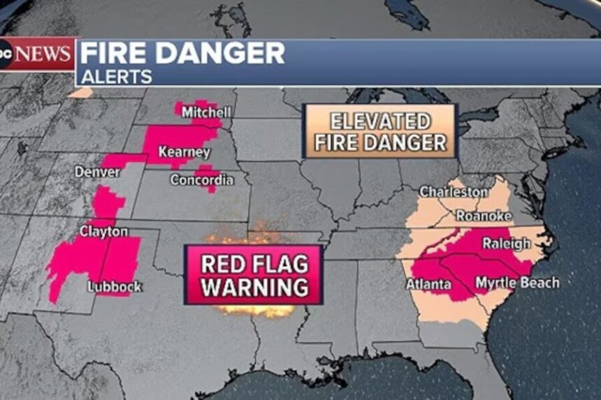
Red flag warnings — issued when conditions are ideal for wildfires to ignite and spread rapidly — were in place Friday for parts of the Southwest, including New Mexico and north-central Texas. Wind gusts in these regions were expected to reach up to 40 mph, coupled with relative humidity levels plunging to just 10%.
In New Mexico, firefighters continued to battle the Gail Fire, which had burned 108 acres and was 25% contained as of Friday, according to local fire officials. The blaze is being driven by wind and bone-dry vegetation, and crews are working around the clock to prevent it from spreading further.
The situation was similarly dangerous in the southern half of Missouri and the northern half of Arkansas. Red flag warnings were issued for these areas, with wind gusts forecast to reach up to 45 mph and humidity levels hovering between 20% and 25%. According to the Arkansas Forestry Division, 96 wildfires have been contained across the state, but four new fires were reported as active on Friday.
“We are mobilizing all resources and working closely with local, state, and federal partners,” the Arkansas Forestry Division said in a statement, urging residents to refrain from outdoor burning and to report any signs of smoke or fire immediately.
Meanwhile, Southeast Florida is also facing critical fire weather conditions. Red flag warnings stretch from Orlando to Stuart, while fire danger remains elevated from West Palm Beach to Miami. With relative humidity as low as 20% and winds picking up, fire officials warned that even a small spark could lead to a fast-moving blaze.
In Miami-Dade County, the 344 wildfires continued to grow on Friday. The fire, which is burning in mostly unoccupied areas of the Everglades, has already scorched 25,000 acres and was only 30% contained as of Friday afternoon, according to emergency management officials.
Smoke from the fire led to the closure of U.S. Highway 1 in both directions. Earlier in the day, a multi-vehicle crash on the highway injured four people, including a child, Miami-Dade Fire Rescue confirmed. Officials cited low visibility caused by wildfire smoke as the contributing factor.
As firefighters race to contain existing blazes and prevent new ones, the nation is also bracing for a powerful cross-country storm. The storm system began moving through the Pacific Northwest on Friday, bringing with it a mix of heavy rain and mountain snow.
Forecasters said Oregon’s mountain regions could receive up to 10 inches of snow by the end of the day Friday, while Idaho and western Montana are expected to see between 8 and 16 inches of snowfall Friday night into Saturday morning. The storm is forecast to intensify and push eastward throughout the weekend.
By Sunday, strong to severe winds ranging from 40 to 60 mph are expected across the Great Plains and upper Midwest. These winds could lead to dust storms, ground blizzards, and widespread power outages, with the potential to down trees and power lines. The conditions also pose a risk to drivers, especially in open areas with little windbreak.
Meteorologists say the storm will bring a wide range of hazards, including heavy snow in the North, powerful winds in the Midwest, and potentially severe thunderstorms across parts of the South. The combination of warm and cold air masses colliding across central regions is expected to create ideal conditions for intense weather activity.
At the same time, a blast of cold air has triggered frost and freeze warnings across the Southeast. Central Mississippi, nearly all of Alabama, and most of Georgia were under warnings Friday morning, with temperatures expected to dip below freezing overnight. Farmers and gardeners were urged to take precautions to protect crops and sensitive plants.
“This is a highly dynamic and dangerous weather pattern,” said National Weather Service meteorologist Kelsey Ramirez. “We’re seeing a combination of fire, frost, and storm threats unfolding across the country at the same time.”
Emergency agencies across the U.S. are preparing for a busy weekend, with additional resources being deployed in vulnerable areas. State and local governments are coordinating closely with FEMA and other federal partners to ensure rapid response to fires and storm damage.
The recent surge in wildfire activity, paired with fast-moving storms and record-low humidity levels, highlights the growing frequency of extreme weather events across the country. Climate experts say longer dry seasons, stronger wind patterns, and rapid temperature shifts are contributing to the increase in fire risk and weather volatility.
With multiple regions under threat, officials are urging the public to stay informed through local weather alerts, avoid any activity that could spark a fire, and prepare for possible power outages or evacuation orders.
As the weekend progresses, all eyes will remain on both coasts — where fires continue to rage and storms are just beginning to build.