A powerful and slow-moving storm system is hammering the southeastern United States this week, unleashing torrential rains, triggering flash flood warnings, and creating widespread disruptions from the Gulf Coast up through Virginia.
Beginning Monday, the system has already dumped inches of rain across several states, prompting flood watches and advisories stretching from Florida to the Carolinas. Meteorologists say the danger is far from over. About 36 million people along the Eastern Seaboard remain at risk of severe weather, including damaging winds, hail, and isolated tornadoes, according to the Storm Prediction Center.
AccuWeather forecasts predict that a dozen states could see over 2 inches of rain in the coming days. Parts of southern Georgia, Alabama, and especially Florida may receive up to 10 inches, nearly two months’ worth of rain in less than a week. The flood potential is particularly high in South Florida, central Alabama, and the Carolinas, where saturated soil and overwhelmed waterways raise the risk of flash flooding.
In North Carolina, up to 4 inches of rain had already fallen by Monday afternoon. The National Weather Service office in Morehead City warned that conditions posed “life-threatening flash flooding of creeks and streams, urban areas, highways, streets, and underpasses.” Officials there say the state could be seeing its heaviest rain since Hurricane Helene in 2018.
The storm system is also being blamed for a severe weather outbreak over the weekend, which produced tornadoes that struck areas of Florida, including Destin and Esto, leaving widespread damage.
The impact of the storm isn’t limited to rainfall. Across Florida, Georgia, and Alabama, more than 20,000 homes and businesses lost power as of Monday, with Florida experiencing the most outages. Miami-Dade and Broward counties alone reported over 3,000 customers without electricity, according to PowerOutage.us.
Meanwhile, major airports have begun experiencing significant delays. Miami International Airport saw over 40 flight cancellations and around 160 delays, with average departure wait times reaching 90 minutes. The Federal Aviation Administration warned of possible ground stops at airports in Tampa, Miami, and Atlanta as the storm progressed.
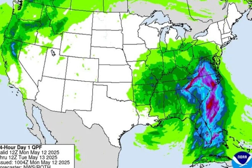
In just 24 hours prior to Monday, a wide region including central South Carolina and eastern Georgia received 3 to 6 inches of rain. Localized areas between Appling, Georgia, and Barnwell, South Carolina, reported as much as 10 inches. These rainfall levels led to scattered flooding in low-lying communities, including Hampton, Orangeburg, Lexington, and Richland, South Carolina, as well as near Savannah, Georgia.
Forecasters expect the storm to slowly shift northward through the week, bringing the flood threat to the Mid-Atlantic. Virginia, Maryland, and Washington, D.C., are expected to see prolonged rainfall that could overwhelm urban drainage systems and lead to additional power outages.
Emergency officials are urging residents in affected areas to remain alert, monitor local weather alerts, and avoid driving through flooded roadways. Authorities also recommend preparing emergency supplies and ensuring communication devices are fully charged in case of outages.
This storm’s reach and impact are reminders of the region’s growing vulnerability to intense, sustained weather systems. Experts note that with climate patterns shifting, such widespread and persistent storms may become more common, bringing with them greater risks to infrastructure, communities, and everyday life.